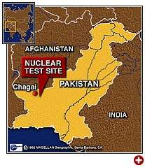
Site of Pakistan Nuclear Tests.
Note the area where my wife, Honzagool, lives. Look at the top of the map of Pakistan. You will see an "<" shape pointing into Afghanistan. The lower edge of that < shape is where the house of Honzagool is located.
|
Site of Pakistan Nuclear Tests. Note the area where my wife, Honzagool, lives. Look at the top of the map of Pakistan. You will see an "<" shape pointing into Afghanistan. The lower edge of that < shape is where the house of Honzagool is located. |
The next map shows the exact location of the house of Honzagool. The main way to get to her house is to cross 10,200 foot high Lowari top from Dir and upon reaching the main river down at Mirkani, turn right and proceed five miles up to Drosh. Cross the Chitral River at Drosh and then come three miles back down the river. After crossing Jinjoret River (actually just a small stream) you will see a small graveyard to the left side of the road. In the distance across from the graveyard is the house of Honzagool.
When you cross the Chitral River at Drosh, the road forks just after you cross the bridge. Take the left branch. Go three miles down the road. There used to be an airport off to the left but it was abandoned as being too close to the Chitral River. After three miles, you will cross a small stream. This stream is called Jinjoret Kuh. Just across the stream you will see a small graveyard to the left side of the road. In the distance across from the graveyard are three connected houses with a tin roof. The middle one is the house of Honzagool.
However, to reach there, go a few hundred yards more down the road to the village of Damik. Get out there. Walk back from Damik along the top edge of the hillside. There will be a long wall to your left and a hill down to your right and rice fields down at the bottom of the hill where the mother of Honzagool sometimes works.
About the third door back along the long wall, the next to the last door will be the back entrance to the house of Honzagool.
Another way to reach the same place is, coming from Lowari Top, you can turn left at Mirkani, go three miles downstream to Nagar, cross the bridge at Nagar, and then go five miles upstream reaching the house of Honzagool. That is the way I went when I needed to reach her house in 1983 undetected.
 Map of Nuristan - Please be thankful for this map, because maps of this area were illegal to sell either in Afghanistan or Pakistan.
 Go up the Kunar River. When it crosses the red dotted line (very hard to see) you have gone from Afghanistan back into Pakistan. If you do not cross the dotted line but take the smaller river to the left, you reach the valleys of Nuristan. If you want to go visit my wife, Honzagool, you cross the red dotted line, keep to the left (West) side of the river, and you will see two rivers branching West near the brown line which comes from the word MUMO. The first river is called Urtsun. The second river is called Jinjoret. Honzagool lives between the Urtsun and Jinjoret rivers, but much closer to Jinjoret. There is a small bend in the river < which is the exact spot where the house of Honzagool is located. This map is Copyright © 1997 by Richard F. Strand. |
Peshawar, Pakistan is located at 34° 1' N 71° 35' E . Chitral is 180 miles north and a bit east of Peshawar. Honzagool lives 29 miles southwest of Chitral town.
Peshawar, Pakistan
Location: 34:00:00N 71:30:48E
Kabul, Afghanistan
Location: 34:34:01N 69:13:01E
Chitral town is at approximately 36:00:00N 72:00:00E or Long 71.807 Lat 35.882
Here are links: